
 Ribbon: Topoplan – Geopoints >
  Creating Geopoints by Surface
Menu: Topoplan – Geopoints > Creating Geopoints by Surface
Toolbar: GeoPoints > Creating Geopoints by Surface
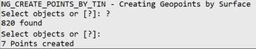
 Command line: NG_CREATE_POINTS_BY_TIN
The command creates new geopoints at the nodes of surface faces. Geopoints take X, Y, Z coordinates from surface nodes. The geopoint style is assigned by default (Standard).
Command prompts:
| Select objects or [?]: | Select a surface in the drawing field. |
|---|
The command line will display the number of points created.
The command has no options.
Feedback
Copyright © 2026 CSoft AS
—
Powered by 
Post your comment on this topic.