
Import elevation grid
 Ribbon: Topoplan – Create TIN >
  Import elevation grid
Menu: Ground – Creating TIN > Import elevation grid
Toolbar: Creating TIN > Import elevation grid
 Command line: NG_IMPORT_ELEVATIONGRID
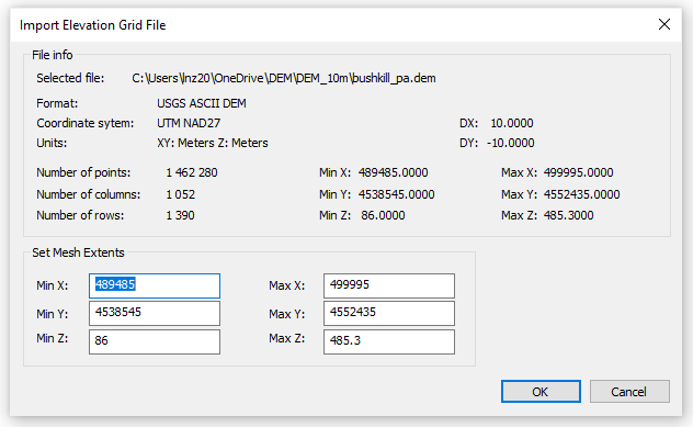
To create surfaces in the module it is possible to load elevation grid files in PGM, GRD, ASC, DEM formats. As a result of the import, a surface is created in the form of a Mesh object.
After starting the command, a standard file selection dialogue box will open. It is necessary to specify the file and click OK.The import dialogue will open:
The command options are set in the Properties toolbar.
Options:
| Split mesh for optimization | If this option is enabled, for more convenient work the mesh will be split into several smaller objects. It is recommended to enable this option. |
|---|---|
| Convert to CS | If the elevation matrix was created in WGS-84 system, them its conversion is required to display in a drawing’s rectangular coordinate system. Possible variants: UTM (Universal Transverse Mercator), СК-42, СК-95. Also, it is possible Do not convert the elevation matrix, but it is recommended not to use this option. |
In case the command is performed successfully, the message will appear:
Import evaluation grid done!
Info: NanoCAD is a user friendly, low cost, and yet powerful, CAD app for PC, that provides a great user experience by providing enhanced performance, full capability, a classic interface and native.dwg format support. nanoCAD has been built to deliver design and project documentation for all industries. nanoCAD includes a full suite of basic and advanced CAD tools for 2D/3D drawing and creating industry-standard DWG-compatible CAD files. Our software ensures progressive, collaborative and customizable features to boost your efficiency, and includes a number of API’s, allowing anything from routine task automation to complex CAD app development. You may download nanoCad for free, using the links below, and buy later, in case you like it.
Post your comment on this topic.