
Correction of zero elevation
 Ribbon: Topoplan – Relief >
  Correction of Zero Elevation
Menu: Ground – Elevation > Correction of Zero Elevation
Toolbar: Elevation > Correction of Zero Elevation
 Command line: NG_ADJUST_ZERO_ELEVATIONS
The command changes the elevations (Z coordinate) of a 3D polyline, aligning them in the range from one valid elevation to another using the linear interpolation method.
When running the command, specify 3d polyline in the drawing and press Enter. The nodes the Z coordinates of which had 0 value, will be corrected.
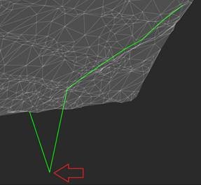
NOTE: Zero values of Z coordinates of endpoints of 3d polylines will be corrected for non-zero values of Z coordinates of adjacent points.
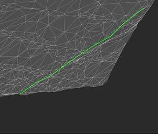
Node of 3D polyline that needs correction  3D polyline after correcting elevation
Info: NanoCAD is an easy-to-use, inexpensive, and yet powerful, CAD app for personal computer, that allows an outstanding user experience by providing high performance, full capability, a classic interface and native.dwg format support. nanoCAD has been built to deliver design and project documentation for all engineering purposes. nanoCAD includes a full suite of basic and advanced CAD tools for 2D/3D drafting and creating industry-standard DWG-compatible CAD files. Our freeware ensures groundbreaking, collaborative and customizable features to improve your efficiency, and includes a few API’s, allowing anything from routine task automation to complex CAD app development. You may try nanoCad for free, using the links below, and buy later, in case you like it.
Post your comment on this topic.